
|
|
|
|
Nearby Towns & Villages and associated attractions
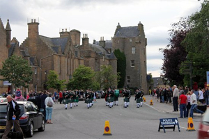
There are a number of quaint little towns and villages in the area. Here are just a few you could visit during your stay. As you will see from the Area map, Invergordon is in a central position allowing access to the north and the south possible. Public buses run through the local area and you should check the Stagecoach timetable for routes and times at www.stagecoachbus.com. The area is also covered by day tickets. We have given an indication of bus numbers and estimated journey times throughout the following list. These are for guidance only - we cannot be held responsible for any changes. Please always check with the bus driver on the day. |
|
|
To The North
|
|
|
|
|
|
To The North
From Invergordon to Brora takes just under 2 hours 30 minutes. 25X will take you from Invergordon to Tain where you will have to change to X99 or X98 to take you further north i.e. Dornoch, Golspie or Brora. Tain is a small town (about 11 miles from Invergordon) which was the birthplace of St. Duthac and his final resting place. Places of historical interest in the town include The Tower, St. Duthus Church and St. Duthuc’s Chapel. The Museum on Chapel Brae has many exhibits relating to Tain’s past and is also the centre of the Clan Ross Association. In 1966 Her Majesty The Queen Mother opened the Rose Garden which was laid out with 900 roses to commemorate the 900th anniversary of the Royal Charter being bestowed by King Malcolm Canmore in 1066. Glenmorangie Distillery is located just north of Tain (about 12 miles from Invergordon). They boast the tallest stills in Scotland and produce around (6,000,000 litres) 10 million bottles per annum. Visit www.glenmorangie.com for further information. Balblair Distillery is located in Edderton (17 miles from Invergordon). The distillery produces 1,700,000 litres of pure alcohol per year, from locally sourced barley. Balblair was used in filming the 2012 film ‘The Angel’s share’. The Angel’s share is so called because during the process when the whisky is left to mature, a small amount of the whisky in the barrel evaporates and the content is reduced by a small amount (up to 2%). As the barrels are air tight and stored under very tight secure warehouse conditions no-one can explain why, when the barrel is finally opened there is less in every barrel than there should be, so myth has it that it must be taken by the Angels, hence ‘The Angel’s Share’! Visit www.balblair.com for further information.
Visit www.visitdornoch.com for further information.
A network of mountain bike trails, the Highland Wildcat Trails, has been built on the side of Ben Bhraggie. This features black and red graded routes, going from the summit of the hill down to the village of Golspie, including the longest single track descent in the UK at around 7 km. Visit www.visitscotland.com/info/see-do/highland-wildcat-trails-golspie-p317471 for further information. Brora was once the main industrial centre in Sutherland having at one time a coal pit, boat building, salt pans, fish curing, lemonade factory, distillery, wool mill, bricks and a stone quarry. Stone from the quarry was used in the construction of London Bridge, Liverpool Cathedral and Dunrobin Castle. When in operation, the coalmine was the most northerly coalmine in the UK. Brora was the first place in the north of Scotland to have electricity thanks to its wool industry. Today, very little remains of these industries apart from Clynelish Distillery to the north of the village. Visit www.brora.name for more information.
Visit www.malts.com/en-gb/distilleries/clynelish for more information. Easter Ross Peninsula, Portmahomack, Tarbat Discovery Centre and the Seaboard Villages can be accessed by taking 25X from Invergordon to Tain and changing to 30C there. The journey from Invergordon to Balintore will take approximately one hour.
Visit www.portmahomackcommunity.org.uk for further information. Easter Ross Peninsula
Tarbat Discovery Centre
Namely (from North to South):
Visit www.seaboardcentre.com for further information. |
|
|
return to the top
|
|
|
To The South
From Invergordon to Dingwall takes approximately forty five minutes on a 25 bus, which will also continue to Inverness taking another forty five minutes.
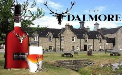
The Dalmore distillery is owned and operated by Whyte & Mackay Ltd and now stands as their largest distillery as well as being the flagship for the brand. With four pairs of stills, Dalmore produces 4,300,000 million litres per annum and employs eighteen staff at peak times, but still retains its quality and character. The legend of The Dalmore dates back to 1263, when Colin of Kintail, Chief of the Clan Mackenzie, saved King Alexander III of Scotland from a charging stag. As a reward the grateful King, granted Colin of Kintail the lands of Eilean Donan, the motto ‘Luceo Non Uro’, which translates to ‘I Shine, Not Burn’ and the right to use the 12-pointed Royal Stag as the Mackenzie clan crest. The lease was taken over in 1869 by three Mackenzie brothers, Alexander, Charles and Andrew. As members of the clan Mackenzie they brought with them the iconic 12-pointed Royal Stag emblem, the caberfeidh, which has adorned every bottle of The Dalmore since. In November 1917 the focus shifted from malts to mines at Dalmore when the Admiralty took over the distillery; the US Navy used the warehouses as factories for the production of deep-sea mines. In 1920 they left the distillery again - mostly in ruins - after an explosion and a fire in the warehouses, but not before some 38,000 mines had been shipped from Dalmore. Long before the legal battle about compensation for the damages between Andrew Mackenzie and the Royal Navy was over (the debate eventually reached the House of Lords in 1925) Dalmore resumed production again.
Visit www.alness.com for further information.
More details of a suggested walk to the top of Fyrish can be found www.walkhighlands.co.uk/ullapool/fyrish-monument.shtml. Evanton is a small village 4 miles from Alness. It is more or less enclosed to the north-east and the south-west by two rivers, the Allt Graad and the River Sgitheach.
Visit www.walkhighlands.co.uk/ullapool/blackrockgorge.shtml for further information. Kiltearn church and burial ground lie on the shore of the Cromarty Firth. The current church is on the main street in Evanton. Visit www.walkhighlands.co.uk/ullapool/kiltearnchurch.shtml for details of a walk round the area. The "naked rambler" Stephen Gough was reported and arrested at Evanton in November, 2003. He was engaged in a naked trek through Britain from Lands End to John O’Groats. While walking through Evanton wearing only a hat, a backpack and boots, he was spotted and reported by a local resident. He was sentenced two months later! His arrest meant that he still had one hundred miles to go in order to complete his journey. He completed his journey in January 2004 and repeated the feat in 2006. The Zulu Herring Boats which were part of the Seaboard fishing fleet before World War 1 are now commemorated by a plaque at Foulis Point on the shores of the Cromarty Firth, strategically placed so as to see the remains of the wrecks at low tide. The boats were left moored there when the Seaboard fishermen answered the call to serve their country, but unfortunately very few of them ever returned and the boats were left to rot. Only three of an estimated dozen or so can be seen to this day – their outlines being visible at low tide about one hundred yards from the shore. Dingwall lies near the head of the Cromarty Firth where the valley of the River Peffery unites with the the mouth of the Conon, 11 miles from Invergordon. It was formerly an east-coast harbour but now lies inland. On the town's present-day outskirts lies Tulloch Castle, parts of which may date back to the 12th century. In 1411 the Battle of Dingwall is said to have taken place between the Clan Mackay and the Clan Donald. The 18th century town house and some remains of the ancient mansion of the once powerful earls of Ross, still exist. An obelisk, 16 metres high, was erected over the grave of Sir George Mackenzie, 1st Earl of Cromartie, near the parish church of St Clement. It was affected by subsidence, becoming known as the "Leaning Tower", and was replaced by a much smaller replica in the early years of the 20th century. However even this is now marked by signs saying "Keep Out" on the grounds that it is a dangerous structure. Dingwall is the home of Ross County Football Club, who won promotion to the highest tier in Scottish football in 2012. Despite the town's small population, The team reached the 2010 Scottish Cup Final, when over 17,000 Staggies fans travelled to the match. They won their first major piece of silverware in 2016 by winning the Scottish League Cup.
The Drover’s Monument commemorates the unique annual migration of livestock, and the unsung heroes who performed it in days gone by. They collected cattle from the Western Isles, Skye or the far North and walked them hundreds of miles to market in all weathers. Some even walked their herds all the way to London to secure the best price. Many of them became cowboys and major ranchers in the U.S. Wild West. Glen Wyvis Distillery. On the 16th April 2016, 270 years to the day after the Battle of Culloden, The Flying Farmer, John Fraser Mckenzie and his board offered the chance to become part of history by inviting members of the public to invest in the distillery. As a result, GlenWyvis Distillery is now the world’s first 100% community-owned distillery. For more information visit www.glenwyvis.com
The Black Isle is even more difficult to visit using public transport. You have to take 25X into Inverness bus station. To reach Beauly and Muir-of-Ord you need a 28 bus from Inverness bus station. The journey will take approximately 1 hour 45 minutes. To reach Cromarty from Inverness take 25D (from Longman Road) to Avoch, Fortrose and Cromarty. The journey to Cromarty will take approximately 2 hours 30 minutes. The Black Isle, despite its name, is not an island but a peninsula surrounded on three sides by water – the Cromarty Firth to the north, the Beauly Firth to the south, and the Moray Firth to the east. It includes the towns of Cromarty, Fortrose and Beauly, and villages such as Muir of Ord and Avoch. Beauly is a small town 10 miles (16 km) west of Inverness. Beauly is the site of the Beauly Priory, or the Priory Church of the Blessed Virgin and John the Baptist, founded in 1230 by John Byset of the Aird, for Valliscaulian monks. Following the Reformation, the buildings (except for the church, which is now a ruin) passed into the possession of Lord Lovat.
Visit www.visitbeauly.com for more information. Muir-of-Ord: is situated near the western boundary of the Black Isle, about 20 km west of the city of Inverness, and 10 km south of Dingwall. The Black Isle Show, one of the largest agricultural shows in Scotland, is held every August in a showground near Muir of Ord. Glen Ord Distillery is located in Muir of Ord. It is the only remaining single malt whisky distillery on the Black Isle. The distillery currently produces 5,000,000 litres of pure alcohol per year. Visit www.malts.com/en-gb/distilleries/the-singleton-of-glen-ord for more information.
Highland Ferries offer a regular ferry service between Cromarty and Nigg with the Renfrew Rose running from June to September, from 8:00 a.m. to 6:00 p.m. daily, offering a direct route North from the Black Isle. Cromarty is architecturally important for its Georgian merchant houses that stand within a townscape of Georgian and Victorian fisherman's cottages in the local vernacular style. It is an outstanding example of an 18th/19th century burgh, "the jewel in the crown of Scottish Vernacular Architecture". The thatched house with crow-stepped gables in Church Street, in which the geologist Hugh Miller was born (in 1801), still stands, and a statue has been erected to his memory. The burgh is also noted as a base for viewing the local offshore sea life. These include one of the most northerly groups of bottlenose dolphins. Fortrose is a town about 6 miles (9.7 km) north-east of Inverness. The town is known for its ruined 13th century cathedral, and as the home of the Brahan Seer. In the Middle Ages it was the seat of the bishopric of Ross. The Cathedral was largely demolished in the mid-seventeenth century by Oliver Cromwell to provide building materials for a citadel at Inverness. The vaulted south aisle, with bell-tower, and a detached chapter house (used as the tollbooth of Fortrose after the Reformation) remain. These fragments, though modest in scale, display considerable architectural refinement, and are in the care of Historic Scotland (no entrance charge). Fortrose shares a golf course with Rosemarkie. Set on the Chanonry Ness the course stretches out into the Moray Firth and offers good views of Fort George. The course is well known for its signature 4th Hole "Lighthouse". The lighthouse in question is the Chanonry Point lighthouse which was designed by Alan Stevenson and was first lit on 15th May 1846.
Avoch is a small harbour-village located on the south-east coast of the Black Isle. Ormond Castle or Avoch Castle was a stronghold built on the site and served as a royal castle to William the Lion; passed on to the Morays of Petty then Archibald the Grim, Lord of Galloway, upon his marriage to Joanna de Moravia in 1362. Descendants of Archibald, were to take the title of Earl of Ormonde from the castle. Legend has it that the village was founded by survivors of the Spanish Armada. Intrepid Scottish-Canadian explorer Sir Alexander Mackenzie, the first European to explore the great Canadian river now known as the Mackenzie River, crossing North America twice, to the Arctic Ocean in 1789 and Pacific Ocean in 1793, retired to Avoch in 1812 where he died in 1820 and was buried in the old Avoch Parish churchyard.
Invergordon to Inverness (direct) Take the public bus, 25X, from Invergordon to Inverness, the journey takes approximately 50 minutes. The direct route between Invergordon and Inverness crosses both the Cromarty Bridge and the Kessock Bridge and bypasses towns such as Beauly, Muir of Ord and Dingwall. The Cromarty Bridge crosses the Cromarty Firth and the Kessock Bridge crosses the Beauly Firth. When the Kessock Bridge was opened, it was the first bridge of its kind in Europe, and won the Saltire Award for Civil Engineering. It was designed by a German and is based on a bridge over the Rhine in Düsseldorf. Inverness – the capital of the Highlands, with a population of around 55,000, was granted city status in 2000 and is situated at the mouth of the River Ness (which flows from nearby Loch Ness). The city lies at the end of the Great Glen with Loch Ness, Loch Ashie and Loch Duntelchaig to the west. The Caledonian Canal also runs through the Great Glen connecting Loch Ness, Loch Oich, and Loch Lochy. Visit http://www.inverness-scotland.com for more information. |
|
|
return to the top
|
|
 Dornoch is a small town situated on the north shore of the Dornoch Firth, near to where it opens into the Moray Firth to the east. Dornoch has the thirteenth-century Dornoch Cathedral (Scotland’s smallest cathedral), the Old Town Jail (now a shop), and the previous Bishop's Palace which is now the Dornoch Castle hotel. Nearby is Royal Dornoch Golf Club, named the 5th best golf course outside the United States in 2005 by Golf Digest magazine. Legendary golf course designer Donald Ross began his career as a greenkeeper on the Royal Dornoch links. It is also notable as the last place a witch was burnt in Scotland. Her name was Janet Horne; she was tried and condemned to death in 1727. There is a stone, the Witch's Stone, commemorating her death, inscribed with the year 1722. On 21st December 2000, Madonna had her son Rocco christened in Dornoch Cathedral, the day before her wedding to Guy Ritchie in nearby Skibo Castle (a private club).
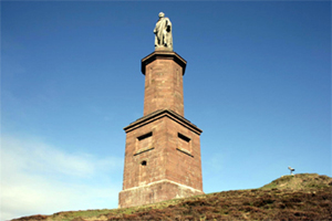 Ben Bhraggie is a hill which rises 397 metres (1,302 ft) above sea level. The hill dominates the skyline above the village of Golspie and is visible from many parts of east Sutherland. The 100 foot high statue which is perched on top is that of George Leveson-Gower, Marquess of Stafford and first Duke of Sutherland who became notorious through the part he played in the Highland clearances. The statue has come to be known locally as The Mannie.

 Portmahomack is a small, picturesque fishing village in Easter Ross, Scotland. It is situated on the Fearn Peninsula. Tarbat Ness Lighthouse is about three miles from the village and Ballone Castle (now a private home) lies about a mile from the village. There is evidence of early settlement and the area seems to have been the site of significant activity during the time of the Picts, early Christianity and the Vikings. The village is situated on a sandy bay, has a small harbour designed by Thomas Telford and has the unusual distinction of being on the east coast but facing west. Portmahomack lies inside the Moray Firth Special Area of Conservation with the associated dolphin and whale watching activity.


 The Seaboard Villages are three small, contiguous coastal villages, situated about 10 km southeast of the town of Tain in Easter Ross. They face east onto the Moray Firth.
 Dalmore Distillery is located just outside Alness (about 3 miles from Invergordon). It sits on the banks of the Cromarty Firth overlooking the Black Isle, the "big meadowland", from which it takes its name.
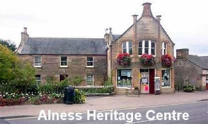 Alness is a small town 3 miles from Invergordon. For most of the 1990’s and early 2000’s Alness regularly entered and won flower competitions such as Scotland in Bloom, Britain in Bloom and others, winning a large number of awards and this also helped regenerate some areas of the town with some housing estates winning separate awards themselves. They have not entered in recent years, however the town is still adorned by flowers maintained by hard working volunteers.
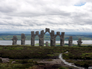 Cnoc Fyrish Stands tall over Alness and rises to 1,478 feet. The imposing monument, at the summit, was built in the 1780’s. It is said to replicate the Gates of Negapatam, a coastal fortress near Madras in India, which General Sir Hector Munro, 8th of Novar (who was raised on the estate) had captured from the Dutch and their Indian allies around 1781.On his return home from India, and as the local population were being cleared off their land, employment was a problem and so it was allegedly built to give the locals some work. It was said that Sir Hector rolled stones from the top of the hill to the bottom, thereby extending the amount of time worked and paying the labourers for additional hours.
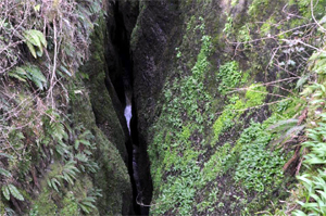 The Allt Graad, sometimes called the River Glass, is a picturesque river that flows from Loch Glass, near Ben Wyvis, for 9 km (5½ miles) until it passes the northern end of the village, and empties into the Cromarty Firth. However, some 3 km (1.9 mi) before it reaches the Cromarty Firth, it passes through the Black Rock Gorge. The latter is a few hundred metres in length and reaches 36 metres (120 ft) in depth. In April, 2004, ten days of filming took place in the area for the movie Harry Potter and the Goblet of Fire and the Gorge is the setting for the scene where Harry is chased by a dragon.
 Major General Sir Hector Archibald MacDonald, KCB, DSO (4th March 1853 – 25th March 1903), also known as Fighting Mac, was a distinguished Victorian soldier. The son of a crofter, MacDonald left school before he was 15, enlisted in the Gordon Highlanders as a private at 17, and finished his career as a major general, "one of only a few British Army generals who rose from the ranks on his own merit and professionalism." He distinguished himself in action at Omdurman (1898), became a popular hero in Scotland and England, and was knighted for his service in the Second Boer War. Posted to Ceylon (Sri Lanka) as Commander-in-Chief of British forces, he committed suicide in a Paris hotel in 1903. MacDonald is often said to have been the model for the soldier who appeared on the label for Camp Coffee. "Fighting Mac" remains a national hero in Scotland. A 100 ft high memorial was erected above Dingwall in 1907, as well as another memorial at Mulbuie on the Black Isle, near where MacDonald was born.
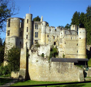 3 miles (5 km) south of Beauly is Beaufort Castle, the chief seat of the Lovats, a modern mansion in the Scottish baronial style. It occupies the site of a fortress erected in the time of Alexander II, which was besieged in 1303 by Edward I. This was replaced by several castles in succession. One of these, Castle Dounie, was attacked and burned by the forces of Oliver Cromwell in 1650 and razed again by the royal army of Prince William, Duke of Cumberland in 1746 during the Jacobite Rising. Simon Fraser, 11th Lord Lovat witnessed this latter conflagration of his castle from a neighbouring hill (he then fled and took refuge in the Highlands before his capture on Loch Morar). In 1994 Simon Fraser, 15th Lord Lovat sold Beaufort castle to Ann Gloag (director of the Stagecoach Group), to pay off debts.
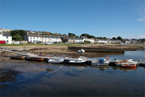
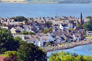 Cromarty is a small town on the southern shore of the mouth of Cromarty Firth, 5 miles (8 km) seaward from Invergordon on the opposite coast. The town grew around its port, formerly used by ferries, to export locally-grown hemp fibre, and by trawlers trawling for herrings. The port was a British naval base during the First World War and HMS Natal blew up close by on 30 December 1915 with heavy loss of life.
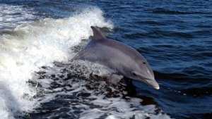 Chanonry Point lies at the end of Chanonry Ness, a spit of land extending into the Moray Firth between Fortrose and Rosemarkie. This is one of the best spots in the UK to view Bottlenose dolphin from the land. The dolphins are often visible off Chanonry point, particularly on an incoming tide when they play and fish in the strong currents. Other wildlife, including porpoises and grey seals, can also regularly be spotted. European otters are occasional visitors.